
 Expeditions Unlimited blog
We are expanding our offering of Himalayan ascents above 7000 meters with Kun in India and Putha Hiunchuli in Nepal. In Ladakh, Nun and Kun are legendary summits above 7000 meters. We have chosen to offer you Kun, as it is less exposed in the event of heavy snowfall. On the Nepalese side, Putha Hiunchuli in the Dolpo region was a natural choice. Its access makes the approach march a true Himalayan expedition in itself, and its ascent, even less technical than Himlung Himal, makes it the ideal first 7000 meter peak.
For all our 7000 meter ascents, we provide one guide per participant, medical support with the Ifremmont hotline, weather routing and 24/7 live tracking of the expedition.
View all our 7000 meter ascents
Ascent of Kun at 7077 meters in Ladakh, India
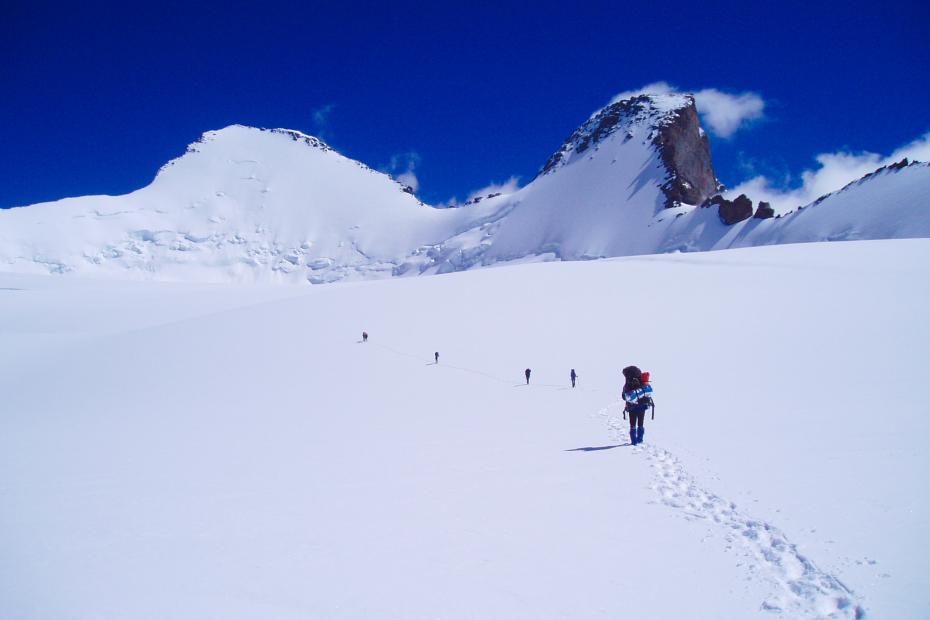 Expedition to Kun in Ladakh ©Jérôme Brisebourg
We set off to climb Kun (7077 m) in the Great Himalayan range, located on the borders of the Indian state of Jammu and Kashmir on one side, and the provinces of Zanskar and Ladakh on the other. Kun is the younger of the twin summits known as Nun-Kun. Its ascent follows the north-east ridge, offering a technical route but with no objective hazards. Nun (7135 m) presents a less technically demanding ascent, but one that is potentially exposed to avalanches, and as a result is rarely climbed. A three-day trek, involving the crossing of the Kanji La at 5280 meters, allows for acclimatisation. An additional day leads from the alpine pastures of Gulmatangol, on the banks of the Suru River, to base camp at 4350 meters.
Two full weeks are dedicated to the ascent, with 2 to 3 reserve days in case of bad weather. Three high-altitude camps are then required to climb the mountain.
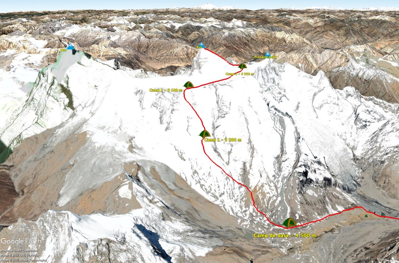
The ascent profile of Kun at 7077 meters in Ladakh, India
The ascent comprises three distinct phases:
- The ascent of the large couloir leading to the vast plateau separating Nun and Kun: we climb for 2 to 3 hours along a moraine leading to the foot of the Shafath glacier. A route through numerous crevasses leads to the foot of the couloir leading up to the great plateau. Camp 1. We then reach the most technical section of the ascent. A mixed and ice couloir with an average incline of 45° leads to the Snow Plateau. The guides fix ropes along the entire length of the couloir to facilitate progress. At the top, we finally discover Kun and Nun (7135 m) on our left. The south-east face of Kun, entirely rocky, will need to be skirted in order to finally catch sight of the route leading to the summit.
- The crossing of the great plateau stretching three kilometers: three kilometers of tedious flat terrain. The day's weather can make it very gruelling: in fine conditions, it quickly becomes very hot; conversely, the wind can blow violently. It is advisable to place markers along the entire route to find one's way back easily in case of bad weather on the return. Little by little, the north-east face reveals itself, and the continuation of the route becomes clear.
- The progression along the magnificent north-east ridge, in a vertiginous setting: the route begins by climbing 40° snow slopes to reach the broad col at 6500 meters, separating Kun from Pinnacle Peak (6930 m). We then follow the north-east ridge, with a dizzying view down the opposite face. The ridge, inclined at 35°/40°, may present short, somewhat steeper steps. The difficulty depends greatly on the quality of the snow and ice. In some years, almost the entire ridge must be equipped with fixed ropes.
The favourable period to climb Kun covers the months of July, August and September.
View the trip and our departures
Ascent of Putha Hiunchuli at 7246 meters in Nepal
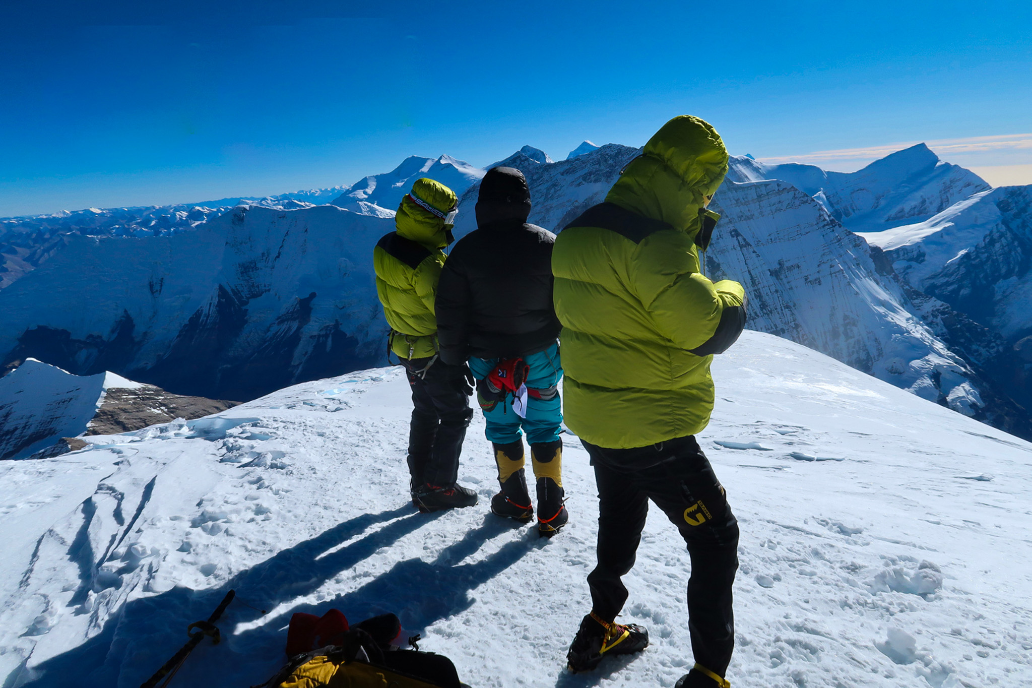 Ascent of Putha Hiunchuli in Nepal ©Rishi
We set off to tackle Putha Hiunchuli, a beautiful and particularly wild 7000 meter summit. Its ascent requires experience of high-altitude expeditions and technical mountaineering skills at a "slightly difficult" level on snow. Putha Hiunchuli is an interesting peak for those looking to discover high altitude. Technically simpler than Himlung Himal (7126 meters), it stands apart through a more complex approach and therefore lower crowds. This isolation gives it its true value, it is far from the masses that crisscross the Khumbu or the flanks of the Annapurnas. Ideal for a truly rewarding expedition. This mountain offers mountaineers drawn to climbing a 7000 meter peak an excellent opportunity to train with the goal of one day summiting an 8000 meter peak. Putha Hiunchuli (7246 meters) is one of the most beautiful mountains in Nepal. Located at the western end of the Dhaulagiri range (8167 m), it is sometimes called Dhaulagiri VII. The Dhaulagiri range is composed of some of the most impressive summits in the world. Within this range, situated west of Annapurna and south of Ganesh Himal, lies a long ridge at the far end of which stands the serene Putha Hiunchuli. It can receive significant snowfall, making its ascent especially physically demanding. The approach march offers a superb trek that allows for gentle acclimatisation. Our trek begins at Juphal-Dunai, approximately one week's walk from the German base camp situated at 4700 meters altitude. The landscape during the approach march is as enchanting as it is unique, a mineral world of high cliffs and deep canyons. The ascent itself is carried out over three high-altitude camps. The regular snow slopes leading to the summit can be skied if conditions are favourable.
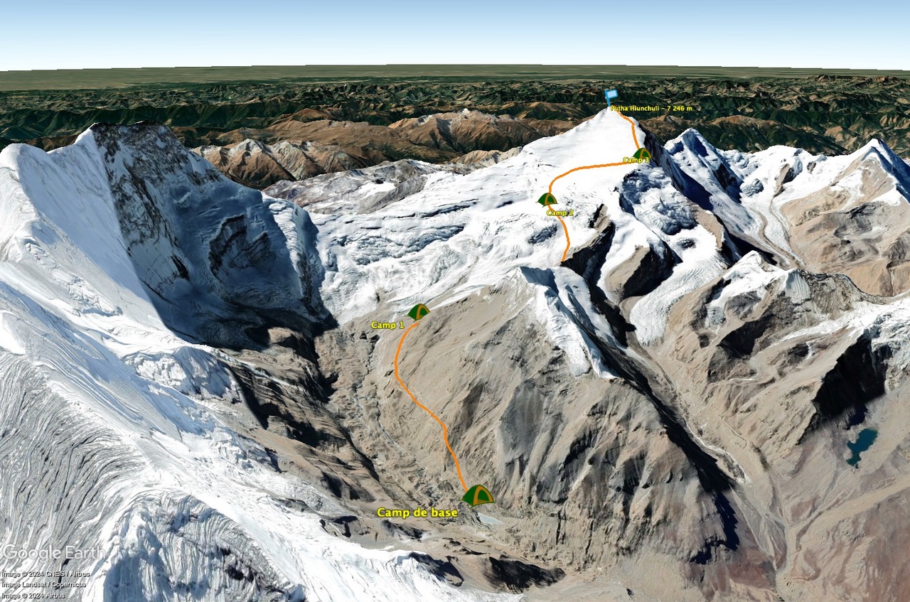
The ascent profile of Putha Hiunchuli at 7246 meters in Nepal
The ascent consists of 3 camps before the summit push:
- Base camp – Camp 1: The ascent begins at approximately 4900 meters, at the base camp situated in a vast glacial valley. The route to Camp 1 (5450 meters) crosses moraines and gentle snow slopes. This first stage, although moderate in incline, can be demanding due to the altitude. Progress is made on snowy slopes or rocky paths, depending on the season's conditions.
- Camp 1 – Camp 2: The section between Camp 1 and Camp 2 (6125 meters) is the most arduous part of the ascent. Here, progress is made on somewhat steeper slopes, sometimes covered in snow or ice. Crevasses are frequently encountered in this section, requiring the crossing of snow bridges or the installation of one or two fixed rope lengths for safety. The slope incline can reach 30 to 40 degrees. Camp 2 is generally situated on a snowy plateau or a sheltered ridge, offering a breathtaking view of the surrounding mountains.
- Camp 2 – Camp 3: The ascent from Camp 2 to Camp 3 (6600 meters) requires less effort. The snow and ice slopes leading towards the summit are easily negotiated, even on skis. Only a possible build-up of snow can slow progress. Camp 3 is often established near a ridge, where winds can be violent, but it is the last stage before the final summit push.
- Camp 3 – Summit (7246 m): Summit day begins very early, often around midnight or 1 AM. The climb presents few difficulties, only wind can interrupt progress. Progress is made traversing gently inclined snow domes. The fatigue caused by altitude and extreme conditions makes this final stage particularly challenging. The effort is constant, but the views become increasingly spectacular as you approach the summit. Once at the top, mountaineers are rewarded with a 360-degree view over the Annapurna range, Dhaulagiri and other Himalayan summits.
The favourable period to climb Putha Hiunchuli is spring and more particularly autumn.